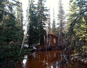
Back cabin, high water
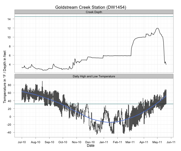
I started measuring the depth of Goldstream Creek a little over a year ago this week. Each morning I measure down from a particular spot on the bridge over the Creek to the top of the water or ice and report this (plus daily high and low temperature, precipitation, snowfall and snow depth) to the Weather Service. The following plot (if nothing shows up, click the following links to view a PNG or PDF version) shows the depth of the Creek at our swimming hole on the top, and the daily high and low temperatures on the bottom. The dark cyan line on the top plot is the height of the bridge (about six feet below the entrance to our house), and the dark cyan line on the lower plot is the freezing point.
At it’s highest, the Creek was just over two feet from the bottom of the bridge, the slough flooded into the dog yard about two thirds of the way across the lowest point, and the Creek seemed dangerously close to topping the banks. The photo at the top shows the back cabin during the high water event.
This year’s breakup was similar to last year: ground and meltwater from the surrounding area started flooding on top of the ice and over the course of a couple weeks, it eroded the ice below until the water level rapidly dropped to more normal summertime depths. One interesting note is that we seem to get a large pulse of water (the rise starting around March 11th) before the snow has started melting, which would seem to indicate that the first pulse is coming from groundwater sources. We don’t start getting afternoon temperatures above freezing until the beginning of April, and this is when snowmelt starts bringing the level up even higher.
When the level begins to drop, it’s pretty dramatic as we go from bankfull conditions to almost nothing in a week. This year we’ve still got wide shelves of ice hanging on the banks six feet above the level of the water.
The plot also shows the brief ice storm in late November where we got a couple inches of rain that froze on the roads and brought the Creek up slightly.
In the past, we’ve had more dramatic breakups where the initial springtime pulse of ground and meltwater breaks up all the ice in a couple days and sends it past our house crashing and grinding, but even the more gradual melting pattern of the last two years is impressive in how quickly the Creek rises and falls.

Hanging ice along the Creek
The Creek has been flowing for what seems like months now, but up until a couple days ago it was a foot and a half of water flowing on top of a frozen Creek bed. Over the last two days the water level has dropped at least three feet, probably because the ice underneath crumbled and melted away. Now there’s a thick band of ice along the banks, hanging above the water flowing through the middle.
This is all very different from the past two years when the water and ice all broke up at the same time, resulting in a very rapidly moving Creek filled to the top of the banks with an enormous amount of water and crushed ice. I was looking forward to that this year, but it’s been such a mild breakup that seeing the Creek suddenly drop down to summer levels is a little disappointing.

Tamarack buds
At least it’s not snowing anymore and things are starting to get green. Most of the birch trees and shrubs have buds that are just beginning to open. There are also several large Tamarack (American larch, Larix laricina) around that are beginning to show signs of leafing out. Tamarack is one of my favorite trees; a deciduous conifer that looks like an evergreen tree in summer but drops it’s leaves in winter. I’d never looked carefully at the buds in the spring—the photo isn’t the greatest representation, but what you’re looking at are the bright green leaf buds, and purplish buds that I think will turn into cones. They’re a very striking tree once their bright green foliage comes out, and I’m eager to see what happens with the cool purple buds that dot the spindly branches right now.
The photo of the Creek at the top of the post (click on the image for a larger view) is a set of nine photos joined together by the AutoStitch iPhone app into a panorama. You can see that it should have been composed of ten photos so the lower left corner could be filled in. In my mind I’d envisioned a sort of running band of photos along the Creek, but it didn’t turn out quite the way I saw it.